
Are you a cycling enthusiast looking for an adventure in the Southwest? Look no further than Arizona. Lake Havasu to Phoenix shuttle service With its diverse landscapes and stunning scenery, the state offers some of the best bike routes in the country. And the best part? Many of these routes are easily accessible by intercity transport. Distance between Phoenix and Lake Havasu In this guide, we'll take you through some of the best bike routes in Arizona and how to get there by Arizona shuttle.
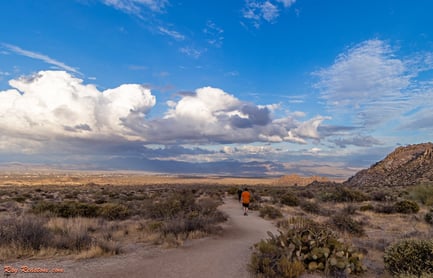
The Arizona Trail
The Arizona Trail is an 800-mile-long trail spanning the entire state, from the border with Mexico to Utah. The trail is a mix of single-track, dirt roads, and paved roads and takes riders through a few of the most scenic parts of Arizona. Some of the most popular sections include the passages through the Santa Catalina Mountains and the Coconino National Forest. While riding the entire trail is an epic adventure, plenty of shorter sections make for great day trips.
Accessing the Arizona Trail
To access the Arizona Trail:
- Take the Arizona Shuttle to Flagstaff or Tucson. Traveling from Phoenix to Flagstaff
- From Flagstaff, take the shuttle to the trailhead at Schultz Pass Road.
- From Tucson, take the shuttle to the trailhead at the Gordon Hirabayashi Recreation Site.
The Loop in Tucson
The Loop is a 131-mile-long system of paved bike paths that circles around Tucson. The Loop takes riders through some of the city's most scenic areas, including the Rillito River Park and the Julian Wash Greenway. The Loop is perfect for cyclists of all skill levels with its flat terrain and wide paths.
Accessing The Loop
To access The Loop, take the Arizona Shuttle to Tucson. Phoenix to Tucson route details You can take the Sun Link streetcar to the Rillito River Park or the Julian Wash Greenway.
The Salt River Trail
The Salt River Trail is a 15-mile-long mountain bike trail that follows the Salt River in Tonto National Forest. The trail is known for its technical terrain and challenging climbs, but the stunning views of the river and the surrounding mountains make it all worth it.
Accessing the Salt River Trail by Intercity Transport
To access the Salt River Trail, take the Arizona Shuttle to Mesa. You can take the Valley Metro bus to the Phon D Sutton Recreation Area trailhead.
Other Bike Routes in Arizona
In addition to these three routes, plenty of other bike routes in Arizona are easily accessible by intercity transport. Some popular ways include the Black Canyon Trail, the Sedona Red Rock Trail, and the Grand Canyon Greenway.
Arizona is a paradise for cyclists with its beautiful scenery and diverse landscapes. And with intercity transport options like the Arizona Shuttle, it's easy to access some of the state's best bike routes. So whether you're an experienced pro or just looking for a leisurely ride, Arizona has something for everyone.
Frequently Asked Questions
Can I book an Arizona Shuttle ride online for a bike trip?
Yes, you can book 24/7 through the website or by phone.
Does the Arizona Shuttle pick me up directly at my home or hotel for bike trips?
Yes, service is door‑to‑door; you provide the pickup address.
Are the Arizona Shuttle rides shared or private?
Rides are shared by default; a private/no‑sharing option is a paid add‑on at booking.
How does Arizona Shuttle handle flight delays when I need a bike trip from the airport?
Flights are monitored and drivers adjust pickup times if there are delays.
Two Wheels, Two Ways: Pedal Power vs. Motorized Adventures
When people search for "Arizona on two wheels," they're usually picturing a road bike or a mountain bike — but in the Sonoran Desert, two wheels come in more than one flavor. Guided ATV and UTV tours have become one of the fastest-growing ways to experience Arizona's backcountry, and operators like Arizona Outdoor Fun, based in the Phoenix area, have built their reputation on direct access to trails like the World Famous Centipede Trail. If your travel crew includes both hardcore cyclists and folks who'd rather let an engine do the climbing, Arizona conveniently delivers both experiences — often within an hour's drive of each other.
Bike Routes vs. ATV/UTV Tours: Which Two-Wheel Adventure Is Right for You?
Here's a quick side-by-side comparison to help you decide how to spend your wheel time in Arizona:
| Factor | Cycling (Road & Mountain Biking) | Guided ATV/UTV Tours |
|---|---|---|
| Best for | Fitness-focused riders, multi-day tours, car-free travel | Families, groups, first-time desert visitors |
| Where to ride | The Loop (Tucson), Arizona Trail passages, Black Canyon Trail | Centipede Trail and Sonoran Desert routes near Phoenix |
| Gear needed | Bring your own bike, helmet, and repair kit | Vehicle, helmet, and safety briefing provided by the operator |
| Guide required? | No — self-guided on most paved and marked trails | Guided and unguided options available |
| Physical demand | Moderate to high, depending on route | Low to moderate — the machine does the heavy lifting |
| Getting there without a car | Arizona Shuttle to Tucson, Flagstaff, or Mesa, then local transit | Shuttle or rideshare to the operator's staging area |
Spotlight: ATV Tours on the Centipede Trail
If you want to add motorized two-wheel (and four-wheel) fun to your Arizona itinerary, Arizona Outdoor Fun is one of the names that comes up again and again among Phoenix-area travelers. The company specializes in guided and unguided ATV/UTV tours, off-road rentals, and shooting range adventures, all designed to get visitors up close and personal with the famous Sonoran Desert.
A few details make this operator worth a look for two-wheel travelers:
- The Centipede Trail. Their advertised Centipede Tour runs Monday through Thursday, with a season running May 1st through January 31st, giving you a wide booking window across most of the year.
- An Ancient Ruins UTV Tour. The company describes this as its most exclusive tour, combining desert riding with a look at archaeological sites.
- Direct trail access. There's no trailering involved — you show up and ride, which is a huge advantage for travelers arriving by shuttle without a truck or trailer.
- Group bookings. Corporate events and groups of 25 or more can be arranged by contacting the operator directly, making it a solid option for team outings or destination weddings.
Reviews from past riders reflect the appeal. One reviewer named Jayden M called it an "experience of a lifetime," while Sheela L wrote that she "would absolutely do this again." Another guest, Carley R, described a three-hour guided trip on side-by-sides as "a fantastic experience" — and if you browse their listings, you'll find a pattern of five-star ratings from riders who say they'd highly recommend the activity. Tour costs vary by vehicle type, group size, and season, so check current rates directly with the operator and budget accordingly.
Combining a Bike Trip with an ATV Tour
Many visitors build a two-wheels-of-everything itinerary. A common approach: spend a morning riding a stretch of The Loop in Tucson or the Black Canyon Trail, then schedule an afternoon or next-day UTV tour near Phoenix. Because Arizona Shuttle connects Phoenix with Tucson, Flagstaff, Mesa, and Lake Havasu City, you can string together a multi-day desert trip without renting a car — just confirm with your shuttle provider that bike transport is available when you book.
When to Ride: Arizona's Two-Wheel Seasons
Timing matters more in Arizona than in most cycling destinations. The low desert around Phoenix and Tucson is at its best from late fall through early spring, when temperatures are mild and the desert blooms. Summer riding in the lowlands starts dangerously early — sunrise departures are the norm — while the high country around Flagstaff and the Coconino National Forest offers a cool-weather escape from June through September. If you're planning an ATV tour, note that the Centipede Tour season noted above runs through January 31st, so winter visitors can still get their off-road fix. Always carry more water than you think you need, regardless of season.
Practical Tips for Two-Wheel Travelers in Arizona
- Hydration is non-negotiable. Desert air is dry, and sweat evaporates before you notice it. Plan on frequent water stops.
- Watch for monsoon season. July through August brings afternoon thunderstorms, flash flooding in washes, and slick trails.
- Know the highway logistics. Popular routes include I-17 between Phoenix and Flagstaff, I-10 between Phoenix and Tucson, and US 60 toward the Superstition Mountains and Tonto National Forest.
- Respect the desert. Stay on designated trails — both for your safety and to protect the fragile desert crust that takes decades to recover.
- Book ahead. Guided tours and shuttle seats both fill up during peak season, especially around spring training and winter visitor months.
Frequently Asked Questions
Do I need experience to ride an ATV or UTV in Arizona?
No. Reputable operators provide a safety briefing and vehicle orientation before every tour, and guided options keep first-timers on appropriate trails.
Can I bring my bicycle on the Arizona Shuttle?
Bike transport policies vary by route and vehicle, so contact the shuttle provider before booking to confirm space for your bicycle and any packing requirements.
Is the Centipede Trail suitable for beginners?
The Centipede Trail is well known among Phoenix-area off-road enthusiasts, and guided tours are designed to accommodate a range of skill levels. Mention your experience level when booking so the operator can match you to the right route.
What's the difference between an ATV and a UTV?
An ATV (quad or four-wheeler) is ridden straddle-style by one person, while a UTV (side-by-side) has seats, a steering wheel, and room for a passenger — a popular choice for couples and families.
Can large groups book two-wheel adventures together?
Yes. Off-road operators in the Phoenix area typically accommodate corporate events and groups of 25 or more with advance notice, so reach out early for group pricing and availability.
What should I wear for a desert ATV tour?
Closed-toe shoes, long pants, sunglasses, and sunscreen are recommended. Operators generally supply helmets and eye protection, but confirm what's included when you reserve.
Is a guided tour or unguided rental better for first-time visitors?
First-time desert riders almost always get more out of a guided tour — local guides know where the terrain gets technical, where wildlife appears, and how to stay safe when temperatures climb.
