
Arizona's remarkable landscapes offer a captivating blend of deserts and mountains. From the sun-drenched deserts to the snow-capped peaks, Arizona beckons with its natural wonders waiting to be explored. With Arizona Shuttle as your guide, you can embark on an exhilarating adventure through the state's diverse terrain.
Saguaro National Park: Iconic Cacti and Desert Beauty
Located near Tucson, Saguaro National Park is a desert oasis adorned with the iconic saguaro cacti. Phoenix to Tucson distance guide The park's rugged landscapes and abundance of wildlife provide a perfect backdrop for capturing breathtaking photographs. Seize the moment to witness a captivating sunset, painting the saguaro-dotted desert with golden hues. Indulge in the Sonoran Desert's splendor as you navigate scenic routes and explore beautiful hiking trails.
Sedona: Red Rocks and Spiritual Energy
Nestled amidst stunning red rock formations, Sedona is a place of extraordinary natural beauty and spiritual significance. Phoenix to Sedona shuttle guide Immerse yourself in the vibrant art scene, browse the galleries, and discover local craftsmanship with our comfortable shuttle services. Embark on a thrilling jeep tour to explore hidden canyons and marvel at the surreal landscapes. Hike to famous landmarks like Cathedral Rock and Bell Rock, and feel the energy of the vortexes, renowned for their spiritual and healing properties.
Grand Canyon National Park: A Natural Wonder of Epic Proportions
Every visit to Arizona is complete with witnessing the grandeur of the Grand Canyon. As you stand on the rim, be prepared to be awestruck by the vastness and sheer beauty of this natural wonder. Take a scenic helicopter ride for a bird's-eye view, hike into the canyon to immerse yourself in its magnificence, or savor the panoramic views from the various lookout points along the South Rim. Each vista offers a unique perspective of the breathtaking landscapes carved by the mighty Colorado River.
Flagstaff: Gateway to Arizona's Mountains
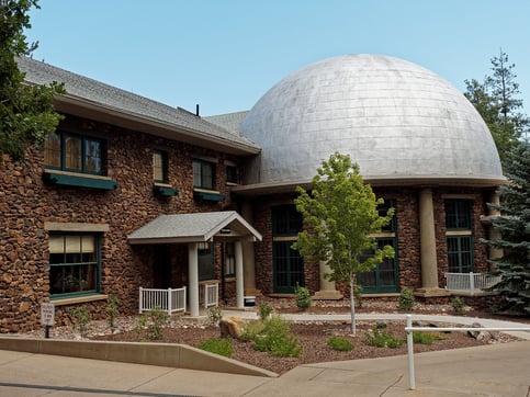
Venture north to Flagstaff, a picturesque city among the majestic San Francisco Peaks. Phoenix to Flagstaff shuttle guide Use Flagstaff as your base camp for exploring the surrounding mountain ranges and forests with our shuttle services. Enjoy hiking trails that wind through pine-scented forests, indulge in winter sports at Arizona Snowbowl, or witness the awe-inspiring night sky at Lowell Observatory. Flagstaff's charming downtown has delightful shops, galleries, and eateries, offering a perfect blend of outdoor adventure and urban comforts.
Arizona's diverse landscapes offer an extraordinary tapestry of natural beauty, from the arid deserts to the majestic mountain peaks. With Arizona Shuttle as your guide, you can embark on an unforgettable journey through this captivating terrain, immersing yourself in the awe-inspiring wonders that await at every turn. Whether you find yourself enchanted by the majestic saguaro cacti in Saguaro National Park, seeking solace and renewal in the spiritual haven of Sedona, amazed by the breathtaking expanse of the Grand Canyon, or exploring the scenic mountain ranges of Flagstaff, Arizona's varied landscapes will etch an unforgettable mark on your spirit.
Route 66 in Arizona: The Mother Road Through the High Desert
No exploration of Arizona's diverse landscapes is complete without a journey down historic Route 66. Arizona holds the longest uninterrupted stretch of the original Mother Road still in existence, and driving it is like rolling through a living museum of Americana. The highway cuts across the northwestern corner of the state, linking towns that grew up alongside the railroad and the automobile age, each with its own personality and its own slice of desert scenery.
Start your Route 66 adventure in Seligman, widely recognized as the birthplace of the road's preservation movement, where vintage storefronts, nostalgic gas pumps, and classic diner fare transport travelers straight back to the 1950s. Continue west through Williams, the charming mountain town that serves as the gateway to the Grand Canyon, then on to Kingman, home to the Arizona Route 66 Museum and a natural stopping point for travelers arriving via US 93. Between these hubs, keep your camera ready for landmarks like the Hackberry General Store, a beloved roadside stop surrounded by vintage vehicles and desert vistas, and the hairpin curves of the mountain stretch near Oatman, where wild burros famously roam the streets of an old mining town.
East of Flagstaff, the route passes Winslow, where the Standin' on the Corner Park pays tribute to the Eagles' classic song, and Winslow's La Posada Hotel, a restored railroad masterpiece. Along the way, the landscape shifts from high-desert grasslands to Ponderosa pine forests to painted mesas — a reminder of just how dramatically Arizona's terrain changes within a single day of driving.
The Arizona Wine Trail: Vineyards in the Desert and Beyond
Many first-time visitors are surprised to learn that Arizona is a serious wine destination. The state's rising wine scene centers on two distinct regions, each offering award-winning wineries and vineyards set against dramatically different backdrops.
The Verde Valley Wine Trail, reached via I-17 and State Route 89A through the scenic Oak Creek Canyon corridor, clusters around the historic towns of Cornville, Page Springs, and Cottonwood. Here, tasting rooms occupy converted farmhouses, creekside patios, and century-old brick buildings in Old Town Cottonwood, all shadowed by the red rock country that makes this corner of the state so photogenic. Because the trail sits within easy reach of Sedona, it pairs naturally with a day of rock-country sightseeing.
The second major region is Sonoita, located southeast of Tucson along State Route 83 in the rolling grasslands of the Sonoita Creek watershed. This high-elevation AVA — one of the first designated American Viticultural Areas in the state — is surrounded by golden prairie and distant mountain ranges, a completely different landscape from the Verde Valley's riparian corridors. Many of the estate vineyards here welcome visitors for tastings and vineyard tours, and the drive itself, winding through wine country and toward the Santa Rita Mountains, is one of southern Arizona's most underrated scenic routes. As travel coverage from MSN and local guides such as Exploring Arizona both note, these two regions showcase how varied the state's agricultural and scenic landscape truly is.
Beyond the Big Four: More Landscapes Worth the Detour
While Saguaro, Sedona, the Grand Canyon, and Flagstaff form the classic Arizona itinerary, the state rewards travelers who venture further. These destinations add even more range to your landscape checklist:
Monument Valley Navajo Tribal Park
On the Arizona–Utah border, the towering sandstone buttes of Monument Valley Navajo Tribal Park define the classic image of the American Southwest. Operated by the Navajo Nation Parks & Recreation, the park offers a scenic loop drive among iconic formations such as the Mittens and Merrick Butte. Guided Navajo-led tours provide deeper insight into the land's cultural significance.
Antelope Canyon and Lake Powell
Near Page in northern Arizona, the sculpted slot canyons of Antelope Canyon — accessible only via authorized Navajo-guided tours — showcase some of the most photographed light beams and swirling sandstone walls in the world. Nearby, Lake Powell and Glen Canyon National Recreation Area add turquoise water and sweeping cliffs to the desert palette.
Havasu Falls and the Sky Islands
Deep within the Havasupai Indian Reservation at the bottom of the Grand Canyon, the turquoise waterfalls of Havasu Creek rank among the most spectacular — and most logistically demanding — destinations in the state, requiring advance reservations and a significant backcountry hike. In the state's southeast corner, the "sky islands" of the Catalina, Santa Rita, and Chiricahua Mountains rise like green archipelagos above the desert floor, offering cooler temperatures, unique species found nowhere else, and hiking opportunities that feel worlds away from the valley heat.
Desert vs. Mountains: Choosing the Right Landscape for Your Trip
Arizona's regions differ not just in scenery but in season, elevation, and pace of travel. This comparison helps you match your itinerary to the experience you want:
| Region | Elevation & Climate Feel | Signature Landscape | Best Season to Visit |
|---|---|---|---|
| Tucson & Sonoran Desert | Low desert; hot summers, mild winters | Saguaro forests, cactus-studded foothills | Late fall through spring |
| Sedona & Verde Valley | Mid-elevation; four mild seasons | Red rock formations, vineyards, creeks | Spring and fall |
| Grand Canyon & Route 66 corridor | High plateau; cool nights, snow possible in winter | Canyon rims, painted desert, pine forests | Late spring through early fall |
| Flagstaff & San Francisco Peaks | Highest elevation city on the route; alpine climate | Ponderosa pine, aspen groves, ski slopes | Summer for hiking; winter for snow sports |
| Sonoita wine country | High grassland; warm days, cool nights | Rolling prairie, vineyards, mountain vistas | Spring through fall |
Planning Your Desert-to-Peaks Route
Arizona's geography makes multi-landscape trips surprisingly efficient. Interstate 17 links Phoenix directly to Flagstaff, passing within easy reach of Sedona via State Route 179 or the Oak Creek Canyon switchbacks on SR 89A. Interstate 40 carries Route 66 travelers across the northern plateau from Kingman to Winslow. Southbound travelers reach Tucson via I-10, connecting to Sonoita wine country via SR 83. Because drives between regions commonly run two to four hours, many visitors structure their trips as loops — desert first, then red rocks, then canyon country — to experience the state's full range without backtracking. Building in a shuttle connection for longer legs lets you enjoy the scenery rather than the rearview mirror.
Frequently Asked Questions About Exploring Arizona's Diverse Landscapes
How many days do I need to see Arizona's main landscapes?
Most travelers should plan at least five to seven days to comfortably experience the Sonoran Desert around Tucson or Phoenix, the red rocks of Sedona, and the Grand Canyon with a Flagstaff stopover. Adding Route 66 or Sonoita wine country typically requires a few more days, since both regions sit at opposite ends of the state.
What is the best time of year to explore Arizona?
Spring (March through May) and fall (October through November) offer the most comfortable conditions across nearly every region. Summer is ideal for the high-elevation north — Flagstaff, the Grand Canyon's North Rim, and Page — while winter is the prime season for low-desert destinations like Tucson.
Where can I drive the original Route 66 in Arizona?
Arizona preserves a long, drivable stretch of the original road between Seligman and Kingman, plus well-marked segments through Williams, Flagstaff, and Winslow along I-40. Historic Route 66 associations and local museums in these towns provide maps and context for the journey.
Which Arizona wine region should I visit first?
Choose the Verde Valley if you are based near Sedona or Flagstaff — its tasting rooms in Cornville, Page Springs, and Cottonwood are close together and easy to pair with red rock sightseeing. Choose Sonoita if you are coming from Tucson or exploring the state's southern sky islands, where the wide-open grassland setting offers a distinctly different experience.
Can I see snow and saguaro cacti on the same trip?
Yes. Because Arizona's elevations range from below 1,000 feet in the southwest desert to over 12,000 feet atop the San Francisco Peaks, travelers can stand among saguaro cacti in the morning and reach snow-covered terrain a few hours later — one of the most striking examples of the state's landscape diversity.
Is Antelope Canyon worth visiting alongside the Grand Canyon?
Absolutely. Page sits roughly two hours north of the Grand Canyon's South Rim area via US 89, making it a natural addition to a northern Arizona loop. Keep in mind that Antelope Canyon requires booking an authorized guided tour in advance, as walk-in access is not permitted.
How do I get around Arizona without driving the whole way?
Shuttle services connect Phoenix Sky Harbor with major destinations including Tucson, Sedona, and Flagstaff, letting travelers cover the long highway segments comfortably while reserving rental cars or local transportation for exploring within each region. This approach works especially well for visitors combining several landscape zones in a single itinerary.
