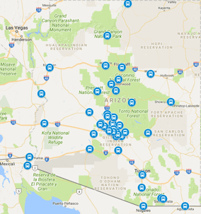
Show Low sits about 175 miles northeast of Phoenix, and the drive between the mountain city and the Valley runs roughly three hours and fifteen minutes door to door in fair weather. The trip climbs the Beeline Highway (AZ-87) from the desert floor through the Mazatzals to Payson, crests the Mogollon Rim, then runs AZ-260 east through the ponderosa country to Show Low. It is the state's Rim-country corridor, carrying cabin owners, summer campers, Hon-Dah visitors, fishing groups, and winter holiday travelers between the White Mountains and Sky Harbor. Because the run is long and the mountain half answers to weather, most of the planning goes into season, daylight, and the return pickup. The how far Lake Havasu City is from Phoenix desert run matches it for length with its own full plan.
The routing: Beeline Highway to the Rim, then AZ-260 east
From the Valley, AZ-87 runs north from Mesa past Fountain Hills and the Four Peaks turnoff, climbing through Sunflower and the Mazatzal grades to Payson at about ninety minutes. From Payson, AZ-260 climbs the Rim past Christopher Creek and Forest Lakes, then descends into the Show Low and Pinetop-Lakeside basin. The Rim climb is the demanding middle: steep grades, passing lanes, elk-crossing zones, and winter snow from November through March. Fuel above half a tank leaving the metro is the standing rule, since the Payson-to-Show Low stretch has limited services after dark. Confirm the exact cabin, lodge, or neighborhood address when booking, because mountain mapping pins drift badly off the main roads.
How long the drive really takes by season
Three hours and fifteen minutes is the fair-weather daylight number. Summer Friday afternoons stretch it as Valley heat-fleers load the Beeline northbound bumper to bumper, and Sunday returns reverse the wave, each adding forty-five minutes to an hour. Winter storms can close or restrict the Rim sections with little notice, turning the trip into a four-plus-hour chain-or-wait affair. Summer monsoon bursts flood the Beeline dips and drop visibility on the grades. Autumn elk season and the fall-color weekends load AZ-260 with slow sightseeing traffic. For airport runs, winter and Friday travel days deserve a full extra hour over the fair-weather number.
Cabin, lodge, and event pickup geography
Pickup geography in Show Low follows the seasons: summer cabin rentals on forest roads with no signage, the lodge and resort properties with lobby loops, winter holiday gatherings in the subdivisions, and the event venues that fill for rodeos and festivals. Share the cabin directions, gate code, and a working phone number when booking, especially for pre-dawn departures when forest roads run dark and cold. Drivers experienced on the Rim corridor plan fuel, daylight, and chain requirements before dispatch. Summer groups with coolers, fishing gear, and camp bins should confirm the full luggage when booking so the vehicle assignment fits everything in one private, non-stop ride.
Sky Harbor timing from Show Low
Sky Harbor recommends arriving about two hours before departure, and boarding usually starts about thirty minutes before takeoff. Against a three-and-a-quarter-to-four-and-a-half-hour drive depending on season, the standard Show Low pickup falls about five and a half to six and a half hours before the flight. That is the longest standard pickup window of any Arizona mountain corridor. Winter travel days and Friday summer departures deserve the full six and a half hours, while fair-weather midweek runs can sit near five and a half. Confirm the airline terminal when booking, since Sky Harbor runs two main terminals on opposite sides of the complex.
Summer escape and winter storm planning
Show Low travel runs on two calendars: the summer escape from May through September, when Valley families trade 110-degree days for pine shade, and the winter holiday season, when snow and ice rule the Rim. Summer travelers should book early-morning departures to beat both the heat and the Friday traffic wave. Winter travelers should check Rim road conditions the night before and the morning of, and keep the phone on so timing can shift if restrictions change. The Sky Harbor airport shuttle return reverses the corridor: south on AZ-260 over the Rim, down the Beeline grades, and back into the desert heat.
Planning the return pickup
Drivers normally meet travelers about 30 minutes after domestic landings and about 45 minutes after international arrivals, which gives checked bags time to reach the carousel. Returns to Show Low after dark climb the Beeline grades at night and cross the Rim in full darkness, when elk move onto the highway shoulders and temperatures drop fast. Share the flight number when booking so timing adjusts if the flight is delayed, and keep the phone on after landing. One booking covers both directions, with free changes to the date, time, address, or flight number if plans move.
Frequently asked questions
How far is Show Low from Phoenix?
About 175 miles via AZ-87 and AZ-260, roughly three hours and fifteen minutes door to door in fair weather. Summer Friday traffic and winter Rim storms can each add an hour or more.
What is the fastest route from Show Low to Phoenix?
AZ-260 west over the Mogollon Rim to Payson, then the Beeline Highway (AZ-87) south into the metro. Keep fuel above half a tank; services thin out past Payson after dark.
How early should I leave Show Low for a flight?
Plan the pickup about five and a half to six and a half hours before departure: up to four and a half hours of driving in season plus the recommended two hours at the airport.
Is there a shuttle from Show Low to Phoenix airport?
Yes, private Show Low airport shuttle service runs the Beeline and Rim corridor in both directions, with cabin pickup, weather-aware timing, flight tracking, and terminal-curb greeting on the return.
3 ways to get from Phoenix to Show Low by car, plane, or shuttle
For most travelers, there are 3 ways to get from Phoenix to Show Low by car, plane, or shuttle. Driving yourself on AZ-87 and AZ-260 gives the most control over stops in Payson, Christopher Creek, and Forest Lakes. Flying into Show Low Municipal Airport (SOW) shortens time on the road. Booking a private shuttle removes the Rim grades, night elk zones, and winter-chain decisions from your day.
| Option | How it works | Best for |
|---|---|---|
| Drive by car | AZ-87 north from Mesa and Fountain Hills to Payson, then AZ-260 east over the Mogollon Rim to Show Low | Cabin stays, fishing gear, coolers, and flexible schedules |
| Fly PHX to SOW | Short plane hop from Phoenix Sky Harbor (PHX) to Show Low Municipal Airport (SOW), then local ride to lodge or cabin | Travelers who want to avoid the full mountain drive |
| Private shuttle | Door-to-door pickup in the Valley, non-stop run up the Beeline Highway and across the Rim, drop at cabin, hotel, or event venue | Airport arrivals, groups, winter travel, and late-night returns |
Find transport to Show Low: what companies run services
When travelers ask what companies run services between Phoenix, AZ, USA and Show Low, AZ, USA, the answers fall into three groups. Rental-car companies and personal vehicles cover self-drivers. Airlines cover the PHX to SOW air link, with schedules that change by season, so check current airlines information before you plan around flights. Shuttle providers cover door-to-door ground service, including Airport Shuttle of Phoenix for Sky Harbor airport shuttle pickups and returns. Compare luggage limits, pickup windows, and forest-road pickup experience before you book, and keep your confirmation and flight number in one place.
Phoenix (PHX) to Show Low Municipal Airport (SOW) flights
Phoenix (PHX) to Show Low Municipal Airport (SOW) flights connect Arizona's largest hub to the White Mountains without driving the Rim. SOW sits just south of town near Show Low Lake, minutes from lodging in Show Low and Pinetop-Lakeside. Because service is regional and aircraft are small, check the airlines page for current days of operation, baggage rules, and whether your plane continues during winter storm periods. If your itinerary uses both a commercial flight and ground transport, share all flights when booking so pickup timing adjusts if the inbound leg is delayed. For trip planning across the United States, confirm terminal and ground-transport information for both PHX and SOW the day before travel.
Need a hotel room in Show Low?
Need a hotel room in Show Low? Base your search on what you came to do. Stay in town near White Mountain Road for restaurants, grocery stops, and easy Hon-Dah Casino access. Choose Pinetop-Lakeside for lodge and resort properties near Fool Hollow Lake and the ponderosa subdivisions. Cabin groups on forest roads outside town should confirm the exact address, gate code, and parking places before arrival, since mapping pins drift off AZ-260 and the side roads. Summer visitors booking hotels for rodeo weekends, fall-color trips, and fishing season should reserve early and confirm check-in terms, cancellation policy, and current prices directly with the hotel. Ask whether your lodge has a lobby loop or a side-entrance pickup point to keep late arrivals simple.
Driving distance calculator and more trip calculations
A driving distance calculator is useful for the related legs around this trip, not just the main run. Trip calculators on sites like TravelMath and MapQuest let you compare Phoenix to Payson, Payson to Show Low, and Show Low to Pinetop-Lakeside as separate segments, which helps with fuel, daylight, and food stops. As a trip planner, break the corridor into states of travel: desert climb from Mesa past Sunflower, Rim climb from Payson past Christopher Creek, and pine-country cruise from Forest Lakes into Show Low. Related route guides like the how far Lake Havasu City is from Phoenix desert run and Sky Harbor airport shuttle hub information help connect mountain and desert plans. For privacy details on quotes and bookings, see the site privacy and terms pages.
Frequently asked questions about Phoenix to Show Low travel
What companies run services between Phoenix, AZ, USA and Show Low, AZ, USA?
Self-drive by rental car, regional airlines into SOW, and private shuttle providers. Airport Shuttle of Phoenix covers door-to-door Sky Harbor service on this corridor.
Is there a plane from Phoenix to Show Low?
Yes, regional flights link PHX to Show Low Municipal Airport (SOW). Check current airlines information for operating days and baggage rules.
Need a hotel room in Show Low — where should I stay?
Stay in Show Low for town access, Pinetop-Lakeside for lodges near the lakes, and forest-road cabins for larger groups. Confirm pickup details with your hotel or host.
How do I use a driving distance calculator for this trip?
Enter Phoenix to Show Low, then add Payson and Forest Lakes as waypoints to compare segments for fuel and daylight planning.
What should groups with extra gear tell the driver?
Share cooler, fishing, camp-bin, and luggage counts when booking so the vehicle fits everything in one non-stop ride.
Where can I find related White Mountains trip information?
Start with the Sky Harbor airport shuttle hub and related distance guides, then confirm current road, airlines, and hotel information before departure.