
Arizona is a state that is famous for its stunning landscapes, from deserts to forests, mountains, and canyons. Phoenix to Chandler shuttle service The best way to experience the state's natural beauty is by taking a scenic drive. Distance from Phoenix With Arizona Shuttle, you can enjoy the views without worrying about driving, traffic, or parking. In this guide, we'll highlight some of the best scenic drives in Arizona that are easily accessible by shuttle.
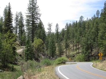
The Apache Trail
The Apache Trail is a scenic drive that winds through the Tonto National Forest, offering stunning views of the Superstition Mountains and the canyon walls. You can stop at the Lost Dutchman State Park, the Goldfield Ghost Town, and the Tortilla Flat Saloon. The route is about 40 miles long and features hairpin turns and steep grades, so it's not recommended for large vehicles or inexperienced drivers.
The Red Rock Scenic Byway
The Red Rock Scenic Byway is a 7. Sedona travel guide5-mile drive through Sedona's stunning red rock formations. The route begins in Uptown Sedona and ends at the Village of Oak Creek. You'll see breathtaking views of Cathedral Rock, Bell Rock, and Courthouse Butte along the way. You can also stop at the Red Rock State Park or hike on one of the many trails in the area.
The Coronado Trail
The Coronado Trail is a 120-mile drive that takes you from Clifton to Springerville, offering some of the most spectacular views in Arizona. The route is known for its hairpin turns, steep grades, and scenic overlooks. You'll see panoramic views of the Gila National Forest, the Mogollon Rim, and the White Mountains. Along the way, you can stop at Hannagan Meadow, Alpine, or the Sipe Wildlife Area.
The Catalina Highway
The Catalina Highway is a scenic drive that takes you from Tucson to the summit of Mount Lemmon, the highest peak in the Santa Catalina Mountains. Tucson to Phoenix The road climbs over 6,000 feet in just 25 miles, offering stunning views of the desert and the mountains. You can stop at the Sabino Canyon, the Windy Point Vista, or the Mount Lemmon Ski Valley.
Arizona is a state that is blessed with natural beauty, and there's no better way to experience it than by taking a scenic drive. Many scenic drives exist, from the Apache Trail to the Red Rock Scenic Byway, the Coronado Trail, and the Catalina Highway. With Arizona Shuttle, you can sit back, relax, and enjoy the views without worrying about driving. So, book your shuttle today and get ready to explore the beauty of Arizona.
Frequently Asked Questions
Is the Apache Trail suitable for all types of vehicles?
The Apache Trail features hairpin turns and steep grades, so it's not recommended for large vehicles or inexperienced drivers.
How long is the Red Rock Scenic Byway drive in Sedona?
The Red Rock Scenic Byway is a 7.5-mile drive that showcases stunning red rock formations in Sedona.
What are some stops along the Coronado Trail?
Along the Coronado Trail, you can stop at Hannagan Meadow, Alpine, or the Sipe Wildlife Area for scenic views and activities.
Does the Catalina Highway offer any viewpoints along the way?
Yes, the Catalina Highway offers stunning viewpoints like Sabino Canyon, Windy Point Vista, and Mount Lemmon Ski Valley.
More Scenic Drives That Showcase Arizona's Scenic Beauty
The Apache Trail, Red Rock Scenic Byway, Coronado Trail, and Catalina Highway are only the beginning. Arizona holds more officially designated scenic byways than most states, and several of the finest are easy to reach from Phoenix or Tucson. Here are the additional drives that deserve a spot on any Arizona itinerary.
Oak Creek Canyon (State Route 89A)
Often called one of the most beautiful drives in the American Southwest, Oak Creek Canyon connects Sedona to Flagstaff along State Route 89A. The winding road follows Oak Creek through a narrow, forested gorge framed by towering red sandstone walls. Popular stops include Slide Rock State Park, where visitors swim in the creek's natural rock slide, and the Oak Creek Canyon Vista Point at the top of the switchbacks, which offers sweeping views back down the canyon. The drive also crosses through for the first few miles the red rock country Sedona is famous for before climbing into ponderosa pine country near Flagstaff.
The Salt River Canyon (U.S. Route 60)
Sometimes nicknamed the "Mini Grand Canyon," the Salt River Canyon stretches along U.S. Route 60 between Globe and Show Low. The highway descends steep canyon walls, crosses a dramatic bridge over the Salt River, and passes through the Fort Apache Indian Reservation on its way into Arizona's White Mountains. This drive pairs beautifully with a visit to the town of Globe or the historic district of Miami, both old copper-mining communities with well-preserved architecture.
Monument Valley and U.S. Route 163
In the state's northeastern corner, U.S. Route 163 approaches Monument Valley Navajo Tribal Park, which sits on Navajo Nation land along the Utah border. The classic stretch of highway south of the park — famous from countless Western films — delivers an unobstructed view of the valley's iconic sandstone buttes rising straight out of the desert floor. Monument Valley itself offers a loop drive through the buttes and mesas, and the adjacent Goulding's Trading Post area provides historical context for the region's movie-making legacy. Because the park is on tribal land, visitors should check current access policies with the Navajo Nation Parks system before traveling.
Historic Route 66 Through Seligman
No scenic tour of Arizona is complete without a stretch of Route 66, and Seligman is the ideal place to experience it. This small town along Interstate 40 is widely recognized as a birthplace of the historic Route 66 preservation movement, and its main street is lined with vintage storefronts, neon signs, and classic roadside Americana. Travelers can continue west from Seligman along the signed Historic Route 66 alignment through Peach Springs and the Hualapai Reservation country toward the Colorado Plateau.
The Desert View Drive (Arizona State Route 64)
Inside Grand Canyon National Park, the Desert View Drive runs about 23 miles along the South Rim from the park's south entrance to Desert View. The route serves several canyon overlooks and ends at the Desert View Watchtower, a stone observation tower designed by architect Mary Colter and completed in 1932. Climbing the tower's interior offers a distinctive framed perspective on the Colorado River far below. Because Grand Canyon National Park manages entry to this route, visitors should confirm current park hours, entry requirements, and shuttle options on the National Park Service website.
Arizona's Scenic Drives at a Glance
| Drive | Route / Highway | Region | Signature Views & Stops |
|---|---|---|---|
| Oak Creek Canyon | SR-89A | Sedona to Flagstaff | Red rock walls, Slide Rock State Park, canyon vista point |
| Salt River Canyon | US-60 | Globe to Show Low | Steep canyon walls, Salt River bridge, White Mountains approach |
| Monument Valley approach | US-163 | Northeastern Arizona / Navajo Nation | Iconic sandstone buttes, classic Western film scenery |
| Historic Route 66 | Seligman stretch | Northwest Arizona | Roadside Americana, vintage neon, preserved main street |
| Desert View Drive | SR-64 (in park) | Grand Canyon South Rim | Rim overlooks, Desert View Watchtower, Colorado River views |
When to Go: Matching Each Drive to the Season
Arizona's scenic beauty changes dramatically with elevation, and timing your drive to the right season makes a real difference in comfort and visibility.
| Season | Best Drives | Why This Season Works |
|---|---|---|
| Spring (Mar–May) | Apache Trail, Red Rock Scenic Byway, Salt River Canyon | Mild desert temperatures and blooming wildflowers in the lowlands |
| Summer (Jun–Aug) | Catalina Highway, Coronado Trail, Oak Creek Canyon | Higher-elevation routes stay cool while deserts get dangerously hot |
| Fall (Sep–Nov) | White Mountains and Coronado Trail, San Francisco Peaks via US-180 | Aspen and oak color at high elevations; comfortable desert weather returns |
| Winter (Dec–Feb) | Desert View Drive area, Monument Valley approach, Route 66 | Crisp, clear air and occasional snow dusting the red rock and buttes |
A note on monsoon season: from roughly mid-June through September, afternoon thunderstorms are common across Arizona. Check the National Weather Service forecast before setting out, avoid flooded roadways, and remember that high-elevation roads such as the Catalina Highway and the Coronado Trail can see snow and ice well into spring.
What You'll See: Arizona's Landscapes by Elevation
Part of what makes Arizona's scenic beauty exceptional is the sheer range of life zones packed into one state. The Catalina Highway alone climbs from saguaro-studded Sonoran Desert floor into pine and mixed-conifer forest — effectively crossing the equivalent of several climate bands in a single morning. Elsewhere in the state:
- Low desert (Sonoran Desert): Iconic saguaro cacti, ocotillo, and palo verde trees dominate the landscapes around Phoenix, Tucson, and Saguaro National Park.
- Mid-elevation canyons and grasslands: Oak woodlands and riparian corridors line drives like Oak Creek Canyon and the Salt River Canyon.
- High country: Ponderosa pine forests blanket the Mogollon Rim and White Mountains, and the San Francisco Peaks near Flagstaff include Humphreys Peak, the highest point in Arizona.
- Painted desert and plateau country: Northeastern Arizona's buttes, mesas, and badlands — including areas within and around Petrified Forest National Park along Interstate 40 — round out the palette.
Wildlife sightings vary accordingly: javelina and roadrunners in the desert, elk and mule deer in the high country, and bighorn sheep in rugged canyon country. Keep a camera ready and stay behind designated barriers and overlooks.
Planning Tips for a Scenic Arizona Road Trip
- Fill the tank before remote stretches. Services along the Coronado Trail, US-163, and portions of Route 66 are limited and far apart.
- Download offline maps. Cell coverage drops out quickly in canyon country and on the Navajo Nation.
- Start early. Morning light flatters red rock photography, and popular Sedona-area trailheads and viewpoints fill up fast in peak seasons.
- Respect tribal lands. Several routes pass through or near Navajo Nation, Hualapai, and White Mountain Apache lands — observe posted rules and photography policies.
- Watch the weather in monsoon season. Never drive through a flooded wash; Arizona's "Stupid Motorist Law" makes drivers liable for rescues in flooded roadways.
- Consider a shuttle for point-to-point legs. If your trip starts or ends at Phoenix Sky Harbor, a Arizona Shuttle ride handles the long highway miles so you can save your energy — and your attention — for the scenic stretches.
Frequently Asked Questions About Arizona's Scenic Beauty
What is the most scenic drive in Sedona besides the Red Rock Scenic Byway?
Oak Creek Canyon on State Route 89A, which runs north from Sedona toward Flagstaff through a forested red rock gorge, is the classic companion drive. Slide Rock State Park and the canyon overlook are the best stops.
Where can I see Monument Valley from the highway?
The iconic view of Monument Valley's buttes appears along U.S. Route 163 on the approach to Monument Valley Navajo Tribal Park in northeastern Arizona. The park itself lies on Navajo Nation land, so confirm current visitor policies with the Navajo Nation Parks system.
Is the Salt River Canyon worth the drive from Phoenix?
Yes. The U.S. Route 60 crossing between Globe and Show Low features steep canyon walls, a dramatic river bridge, and a scenic climb into the White Mountains, making it a rewarding day-trip or stop en route to eastern Arizona.
Can I drive Route 66 in Arizona today?
Yes. Large portions of historic Route 66 remain drivable, and the stretch through Seligman is one of the best-preserved, filled with vintage signage and roadside attractions. Signed historic alignments continue west of town.
What is the Desert View Watchtower at the Grand Canyon?
It is a stone observation tower at the eastern end of the Grand Canyon's South Rim, designed by architect Mary Colter and completed in 1932. It sits at the end of the Desert View Drive (State Route 64 within the park) and is managed by Grand Canyon National Park — check the National Park Service site for current access details.
When is the best time to see fall colors in Arizona?
High-elevation areas such as the White Mountains along the Coronado Trail and the San Francisco Peaks near Flagstaff typically show aspen and oak color in autumn, with exact timing varying year to year by elevation and weather.
How do I see Arizona's scenic drives without doing all the driving?
Book a shuttle for the long highway connections — for example, between Phoenix Sky Harbor and destinations like Sedona or Tucson — and rent a car or join local tours for the short scenic segments. With Arizona Shuttle, the tedious miles are handled for you.
