
Sedona is a popular tourist destination for its stunning red rock formations, rich cultural history, and diverse outdoor activities. One of the best ways to experience Sedona's natural beauty is by hiking its many trails, each offering unique views and challenges. Arizona Shuttle guides the best hiking trails in Sedona, making your visit unforgettable.
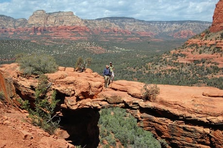
Cathedral Rock Trail
One of Sedona's most popular trails, the Cathedral Rock Trail, offers breathtaking views of the surrounding red rock formations. The trail is just under a mile long and is rated moderate to strenuous due to the steep incline and rocky terrain.
Devil's Bridge Trail
For those looking for a more challenging trail, Devil's Bridge Trail is a must-see. The course is approximately 4.2 miles round trip, features stunning panoramic views of the red rocks, and ends with a picturesque natural sandstone arch.
West Fork Trail
West Fork Trail is perfect for leisurely hiking in a lush, green canyon. The trail is about 6.4 miles round trip and features many stream crossings, towering cliffs, and a variety of plant life.
Boynton Canyon Trail
Boynton Canyon Trail is one of Sedona's most scenic trails, offering stunning red rock vistas and views of the surrounding canyons. The trail is 6.2 miles round trip and is rated moderate due to its length and rocky terrain.
Bell Rock Pathway
The Bell Rock Pathway is a relatively easy, family-friendly hike that offers stunning views of the iconic Bell Rock formation. The trail is about 3.6 miles round trip and is perfect for beginners or those looking for a quick hike.
You can sit back and enjoy the scenic ride to Sedona by choosing Arizona Shuttle, knowing you have a reliable and safe travel option. Our professional drivers know the area and can recommend other activities to enhance your Sedona experience. Sedona airport info Phoenix to Sedona shuttle In addition to hiking, Sedona offers various outdoor adventures, such as horseback riding, mountain biking, and rock climbing. Many cultural and spiritual sites exist, such as the Sedona Vortexes and the Chapel of the Holy Cross. With Arizona Shuttle, you can experience all Sedona offers without worrying about transportation or parking. Our shuttle service is reliable, comfortable, and affordable, making it the perfect choice for your next Sedona adventure. Sedona shuttle service
In conclusion, Sedona's stunning red rock country is a must-see destination for anyone visiting Arizona. By using Arizona Shuttle's guide to the best hiking trails, you can experience the natural beauty of Sedona firsthand. Book your shuttle service today and get ready for a memorable adventure in the heart of Arizona's red rock country.
Why Sedona Is a Hiker's Paradise
Spend even one afternoon among Sedona's red rock country and it becomes obvious why hikers return year after year. The landscape here is a constantly changing series of sandstone formations, slickrock scrambles, shaded canyons, and high-desert mesas — all packed into a compact area around town. Within a short drive of State Route 89A and State Route 179, you can stand beneath the towering spires of Cathedral Rock, wander beneath the cliff walls of Oak Creek Canyon, or watch the sun set from the overlooks on Airport Mesa.
What truly sets Sedona apart is the variety. Easy, family-friendly pathways share the trail map with lung-busting summit climbs. You can hike past ancient Sinagua ruins, peer into hidden caves, cross clear streams under sycamore and cottonwood trees, and spot wildlife like javelina, mule deer, and a wide range of desert birds — often on the same trail network. Add in more than 300 days of sunshine a year, and it's easy to see why Sedona has become one of the great hiking destinations in the American Southwest.
More of the Best Hiking Trails in Sedona
The five trails covered above are only the beginning. This guide shares twelve of the best Sedona hikes, and these seven round out the list — from short canyon strolls to the toughest climb in town.
Bell Rock Climb
Distance: 1 mile | Difficulty: Moderate | Total Ascent: 400 feet | Time: 1 to 2 hours | Trailhead: Bell Rock Trailhead, off State Route 179
Bell Rock is one of Sedona's most recognizable landmarks, and climbing partway up it is a rite of passage for visitors. The first 0.25 miles of the climb are marked with trail signs and wire baskets filled with rock, which help guide you up the lower slopes. Beyond that, the route becomes a choose-your-own-path scramble over slickrock, so turn around whenever the footing feels uncomfortable. This is a fantastic short outing that pairs well with the nearby Bell Rock Pathway.
Fay Canyon
Distance: 2 miles | Difficulty: Easy | Time: 1 hour | Trailhead: Fay Canyon Trailhead, off Boynton Pass Road
If you are looking for an easy, shady stroll through a canyon, put Fay Canyon on your list. The trail gently enters a narrow canyon framed by towering red rock walls, with enough tree cover to make it a good choice on warmer days. Hikers who continue to the end can climb a short, steep stretch to a viewpoint overlooking the canyon.
The Birthing Cave
Distance: 2 miles | Difficulty: Easy to moderate | Elevation Gain: 250 feet | Time: 1 to 2 hours | Trailhead: Long Canyon Trailhead, off Dry Creek Road
To get to the cave, it is a relatively short, flat, and fast hike along an old jeep road at the base of Long Canyon. The payoff is one of the most photogenic spots in Sedona: a concave, cave-like alcove carved into the red rock. For the best photos, bring along a wide-angle lens or try the panoramic feature on your smartphone — the curved walls are best captured from inside the alcove.
Soldier Pass
Distance: 4.5 miles | Difficulty: Moderate | Total Ascent: 800 feet | Time: 2 to 4 hours | Trailhead: Soldier Pass Trailhead
There are several reasons why the Soldier Pass Trail is one of the best hikes in Sedona. Along a single route you can visit Devil's Kitchen, a dramatic sinkhole, the Seven Sacred Pools, a series of small basins that reflect the sky after rain, and the Arches, a sandstone formation with natural windows. Note that the trailhead parking area is small and access is often managed by a reservation or shuttle system, so plan ahead and check current conditions before you go.
Airport Loop Trail
Distance: 3 miles | Difficulty: Easy | Elevation Gain: 400 feet | Time: 2 hours | Trailhead: Airport Mesa Trailhead, off Airport Road
Airport Mesa is a shrub-covered mesa located just south of uptown Sedona, and the loop trail circles it with nearly continuous views of many of the town's most famous formations. Because it is easy, close to town, and offers great sunset lighting on the red rocks, it is one of the best value hikes in the area — though the parking area fills quickly, especially at golden hour.
Bear Mountain
Distance: 5 miles | Difficulty: Strenuous | Total Ascent: 1,800 feet | Time: 4 to 6 hours | Trailhead: Bear Mountain Trailhead, off Dry Creek Road
This may not be the longest hike on this list, but it is the toughest. With 1,800 feet of total elevation gain, Bear Mountain delivers relentless, steep climbs on the way to the summit. The reward is arguably the best panoramic viewpoint in Sedona, with sweeping vistas across the entire red rock landscape. Bring far more water than you think you need, start early, and save this one for a cool morning.
Subway Cave (via Boynton Canyon)
For many hikers, the Subway Cave side route is the highlight of the Boynton Canyon area. It branches off the Boynton Canyon Trail and involves a short, steep scramble up slickrock to a cave-like opening that frames the canyon below. It is not officially signed, so research the route carefully before attempting it, and only go if you are comfortable on steep rock. Those wanting a more exclusive-feeling outing in the same area can also explore nearby.getLonger approaches from Dry Creek Road.
Sedona Hiking Trails Compared
| Trail | Distance | Difficulty | Time | Best For |
|---|---|---|---|---|
| Bell Rock Climb | 1 mile | Moderate | 1–2 hours | Quick iconic scramble |
| Cathedral Rock | 1.2 miles | Moderate | 1–2 hours | Classic red rock views |
| Fay Canyon | 2 miles | Easy | 1 hour | Shady, easy stroll |
| The Birthing Cave | 2 miles | Easy to moderate | 1–2 hours | Unique photos |
| Devil's Bridge | 2 to 4 miles | Easy | 1–3 hours | Natural sandstone arch |
| Airport Loop Trail | 3 miles | Easy | 2 hours | Sunset views near town |
| Soldier Pass | 4.5 miles | Moderate | 2–4 hours | Variety of landmarks |
| Bear Mountain | 5 miles | Strenuous | 4–6 hours | Panoramic summit views |
| West Fork Trail | 6 miles | Easy to moderate | 3–5 hours | Stream crossings, canyon shade |
| Boynton Canyon Trail | 6.2 miles | Moderate | Half day | Scenic canyon hiking |
How to Choose the Best Hike
With so many options, choosing can feel overwhelming. Start with three questions. First, how much time do you have? Short hikes like Bell Rock and Cathedral Rock fit easily into a half day, while Bear Mountain and Boynton Canyon demand a bigger commitment. Second, what is your fitness and comfort level? Trails involving slickrock scrambling, like Cathedral Rock and the Subway Cave, require sure footing. Third, what do you want to see? Water and shade point you toward West Fork; arches and landmarks point you toward Devil's Bridge and Soldier Pass; panoramas point you toward Bear Mountain and Airport Mesa. If you are an avid hiker, plan on spending at least three days in Sedona so you can tackle a real sampling of these trails.
What to Bring on Your Hike
The desert is unforgiving, even on short trails. Pack more water than you expect to drink, salty snacks, sun protection (hat, sunglasses, and sunscreen), and sturdy shoes with good traction for slickrock. A paper map or offline GPS is smart, since some trail junctions are unsigned and cell service can be spotty in the canyons. Photographers should bring a wide-angle lens or plan to use their phone's panoramic mode for the big red rock vistas.
Tips to Have the Best Experience
Timing is everything in Sedona. On a recent visit in April, trails were surprisingly busy — for many hikes, parking lots were filled by 7 a.m., and at Cathedral Rock one of the last spaces was claimed at 6:15 a.m. Arrive early, or hike late in the day between 3:30 and 7 p.m., which works very well and gives you beautiful evening light. Many trailheads require a Red Rock Pass, which costs an estimated $5 per day or $15 for one week — confirm current rates with the Red Rock Ranger District. Some trailheads, including Devil's Bridge, sit on roads accessible only by 4WD high-clearance vehicles; without a 4x4, plan to start from the Mescal Trailhead or walk in from Dry Creek Road.
Responsible Hiking and Trail Etiquette
Sedona's landscapes are fragile and heavily visited. Stay on designated trails to protect the cryptobiotic soil and desert vegetation, pack out everything you pack in, and give wildlife plenty of space. Yield to uphill hikers and to horses, keep noise down so everyone can enjoy the quiet, and never carve into or climb on cultural and archaeological sites. Leave the ruins and rock art exactly as you found them so the next visitor can feel the same sense of inspiration.
Getting to the Trailheads Without the Parking Stress
Trailhead parking is often the hardest part of a Sedona hiking day. Taking a shuttle instead of driving lets you skip the circling-for-spots routine entirely. Our Arizona Shuttle service and Phoenix to Sedona shuttle get you from the airport to your hotel, and our team can help you plan transportation logistics around your hiking itinerary. After a long day on the trail, a reliable ride back is a welcome comfort.
Frequently Asked Questions About Hiking in Sedona
What is the most popular hike in Sedona?
Cathedral Rock and Devil's Bridge are generally the most popular, and hundreds of people per day hike to Devil's Bridge for photos, the views, and even to "pop the question." Arrive very early or go in the late afternoon to beat the biggest crowds.
When is the best time of year to hike in Sedona?
Spring and fall offer the most comfortable temperatures. Summer hiking is best done at dawn, while winter can bring cold mornings and occasional ice at higher elevations. Whenever you visit, start early — trailhead lots fill fast in peak season.
Do I need a pass to park at Sedona trailheads?
Many trailheads require a Red Rock Pass, which costs an estimated $5 per day or $15 for one week. Some trailheads use a reservation or shuttle system instead, so check the current requirements for your specific trail before you go.
Which Sedona hike is best for beginners?
Fay Canyon and the Birthing Cave are excellent beginner options, and the Bell Rock Pathway is a family-friendly choice. Bell Rock Climb is a good introduction to easy slickrock scrambling.
Which hike has the best views in Sedona?
For the effort, Bear Mountain is hard to beat — its 1,800 feet of elevation gain leads to one of the most sweeping panoramas in the area. If you want big views for less work, the Airport Loop Trail and Cathedral Rock deliver outstanding scenery in just a couple of hours.
How many days do I need to hike Sedona?
A half day is enough to sample one or two trails, but avid hikers should plan at least three days. It took experienced hikers several trips and a total of seven days to complete all twelve hikes in this guide.
Can I hike Devil's Bridge without a 4WD vehicle?
Yes. The Devil's Bridge trailhead is on a road accessible only by high-clearance 4WD vehicles, but you can instead start at the Mescal Trailhead or park and walk from Dry Creek Road, adding distance to reach the bridge on foot.
