
Are you looking for a scenic road trip to explore the beauty of Arizona? A journey from Phoenix to Show Low with Arizona Shuttle is the perfect way to experience the natural wonders of Eastern Arizona. This road trip has something for every nature lover, from stunning state parks to national forests. Here are some of the best stops to make along the way.
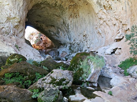
Tonto Natural Bridge State Park
The first stop on this road trip is Tonto Natural Bridge State Park, located in Payson, Arizona. The park features one of the world's largest natural travertine bridges, formed over millions of years. Tonto Natural Bridge State Park guide Tonto Natural Bridge guide Visitors can take a guided hike down to the bottom of the bridge and enjoy the views of the sparkling waterfall and the green foliage.
Petrified Forest National Park
The Petrified Forest National Park is a must-visit destination on this road trip. The park features petrified wood logs over 200 million years old, stunning rock formations, and colorful badlands. Visitors can take a scenic drive through the park, stop at various viewpoints, and hike through the natural wonders. Petrified Forest National Park details Petrified Forest National Park details
Salt River Canyon
The Salt River Canyon is a beautiful scenic drive that takes you through the heart of the Tonto National Forest. The drive offers breathtaking views of the canyon and the river that flows through it. You can stop and take in the stunning scenery from several viewpoints.
Show Low
The final destination on this road trip is Show Low, a charming town nestled in the White Mountains. Show Low shuttle service The city is named after a poker game where the winner claimed the right to name the town. Show Low offers many outdoor activities, including hiking trails, mountain biking, and fishing.
Apache-Sitgreaves National Forest
The Apache-Sitgreaves National Forest is located near Show Low and offers visitors a chance to experience the great outdoors. Apache-Sitgreaves National Forest insights The forest features stunning views of the Mogollon Rim, lush meadows, and a wide range of wildlife. Apache-Sitgreaves National Forest insights Visitors can take a scenic drive through the woods or hike on one of the many trails.
A road trip from Phoenix to Show Low with Arizona Shuttle is a journey that will take you through some of the most stunning natural wonders in Arizona. From the Tonto Natural Bridge State Park to the Apache-Sitgreaves National Forest, there is something for everyone to enjoy. So, pack your bags, hit the road, and get ready to experience the beauty of Eastern Arizona.
Frequently Asked Questions
What can I see at Tonto Natural Bridge State Park?
You can visit the world's largest natural travertine bridge, hike to the waterfall, and enjoy green foliage.
How long should I allocate for Petrified Forest National Park?
A scenic drive with stops and hikes can take several hours to fully explore the park.
Are there any good viewpoints along Salt River Canyon?
Yes, you can stop at various viewpoints to admire the canyon's breathtaking views and the flowing river.
What outdoor activities are available in Show Low?
Show Low offers hiking trails, mountain biking, and fishing for visitors to enjoy the outdoors.
Top 14 Exciting Things to Do in Eastern Arizona
Top 14 Exciting Things to Do in Eastern Arizona
Eastern Arizona stretches beneath the towering Mogollon Rim, a 200‑mile escarpment that rises up to 2,000 feet and marks the southern edge of the Colorado Plateau. The region is laced with historic highways, ancient pueblos, and pristine forests that offer a wide variety of adventures. Below is a curated list of experiences that showcase the natural beauty and cultural richness of this corner of the state.
Now we can insert the comparison table.Scenic Drives: Comparing Eastern Arizona’s Top Routes
| Drive | Route | Distance | Highlights |
|---|---|---|---|
| Coronado Trail | US 191 | 123 mi | Steep climbs to 9,000 ft, panoramic mountain vistas, historic mining towns (Clifton, Morenci). |
| Mogollon Rim Scenic Drive | US 60 / AZ 260 | ~80 mi | Dramatic cliff views, forest‑covered plateaus, numerous overlooks. |
| White Mountain Loop | AZ 273 / AZ 261 | ~50 mi | Alpine lakes (Big Lake, Sunrise), wildlife‑rich meadows, access to ski resorts. |
| Historic Route 66 Segment | I‑40 (Arizona section) | ~150 mi | Retro motels, the Painted Desert Inn (now a museum), desert badlands. |
Item Title
description
We need to incorporate public facts. Now we list:Where the Desert Meets the Mountains
What makes the beauty of Eastern Arizona so remarkable is its dramatic range of elevation. The region is defined by the Mogollon Rim, a 200-mile escarpment rising roughly 2,000 feet and marking the southern edge of the Colorado Plateau. As reported by arizonan.com, the Salt River and Gila River watersheds carve spectacular canyons through this landscape, while the White Mountains climb to elevations exceeding 11,000 feet — creating alpine forests and cool mountain meadows that contrast sharply with the desert terrain just miles away. In a single day of driving along US-60, you can travel from saguaro-dotted Sonoran desert through piñon-juniper woodland into towering ponderosa pines without ever leaving the region.

Layers of Time: The Cultural Heritage of Eastern Arizona
The landscapes here are layered with human history. Spanish explorers arrived in the 16th century, followed by Mexican settlers and, by the mid-19th century, American pioneers who established mining operations, ranches, and farming communities. Long before any of them arrived, the ancestral Puebloans thrived in the region from roughly 950 to 1400 AD, leaving behind sophisticated dwellings, pottery, and rock art that visitors can still see today.
Petrified Forest National Park alone contains more than 800 archaeological sites, including ancient Puerco Pueblo and Agate House, offering a genuine glimpse into the lives of the peoples who once inhabited this land. The park also preserves remnants of historic Route 66, including the famous Painted Desert Inn, which now serves as a museum. Historic trails like the Coronado Trail — now US Route 191 — followed ancient pathways that once connected disparate communities across the region, according to azpaths.com.
Communities with Character: Towns Worth the Detour
Eastern Arizona's towns each tell a different story of the region's past:
- Globe — Founded in 1876, this former mining community retains its historic downtown and makes an excellent stopping point along US-60.
- Clifton — A historic mining town in the state's southeastern corner and the starting point of the Coronado Trail scenic drive.
- Show Low — The White Mountains hub where this road trip ends, named, as legend has it, by the winner of a legendary poker game.
Adventure Awaits: Trails, Lakes, and Summit Views
The Apache-Sitgreaves National Forest, covering over 2 million acres, is the recreational heart of the region. With more than 680 miles of streams and 30 lakes, it is a haven for anglers, hikers, and wildlife watchers alike, as detailed by azpaths.com. Notable trails include:
- Big Lake Loop — An easy 1-mile trail with breathtaking views of Big Lake and the surrounding mountains, ideal for families.
- Mount Baldy Trail — A challenging route to the summit of Mount Baldy, the second-highest peak in Arizona at about 11,400 feet. The trail runs approximately 17 miles round trip through forests and valleys.
- Salt River Trail — A 10-mile hike following the river, popular for wildlife spotting and canyon scenery.
- White Mountain Trail System — More than 200 miles of interconnected trails around Show Low, Pinetop-Lakeside, and nearby communities, allowing you to explore at your own pace.
Comparing Eastern Arizona's Top Destinations
| Destination | Known For | Best For |
|---|---|---|
| Petrified Forest National Park | Trees turned to stone, estimated at about 225 million years old; Painted Desert badlands; Route 66 remnants | History buffs, photographers |
| Apache-Sitgreaves National Forest | Over 2 million acres, 30 lakes, 680+ miles of streams | Anglers, hikers, campers |
| Coronado Trail (US-191) | 123-mile scenic drive climbing from Clifton to over 9,000 feet | Scenic driving, motorcyclists |
| White Mountains | Peaks exceeding 11,000 feet; alpine environment near the desert | Summit hikes, cool-weather escapes |
Planning Your Eastern Arizona Experience
Major routes through the region include US-60, US-70, and US-191, with the latter offering what many consider one of America's most scenic drives through the Coronado Trail section. For most visitors, the Phoenix-to-Show Low corridor via US-60 is the easiest introduction — you can book ground transportation and relax while someone else handles the mountain driving.
A few practical tips:
- Check road and weather conditions before your trip; higher elevations mean cooler temperatures and possible seasonal closures.
- Allow a full day or more for Petrified Forest National Park; a scenic drive with stops and hikes takes several hours at minimum.
- If you want to extend your adventure, consider connecting routes such as the Phoenix to Flagstaff route or the Phoenix to Tucson route for more of the state's natural beauty.
- For longer itineraries, explore our Arizona travel guides hub for route ideas across the state.
Whether you come for the geological wonders, the cultural heritage, or the endless trails, Eastern Arizona rewards travelers who take the time to explore it. Start with the classic Phoenix-to-Show Low journey, then branch out to the Coronado Trail, the White Mountains, and beyond — the authentic Arizona is waiting.
Frequently Asked Questions About the Beauty of Eastern Arizona
What is the Mogollon Rim?
The Mogollon Rim is a 200-mile escarpment rising about 2,000 feet that marks the southern edge of the Colorado Plateau and defines much of Eastern Arizona's landscape.
What is the Coronado Trail Scenic Byway?
The Coronado Trail is US Route 191, a 123-mile stretch in eastern Arizona that starts in Clifton and climbs to over 9,000 feet, offering panoramic mountain and valley vistas.
How high is Mount Baldy?
Mount Baldy stands at approximately 11,400 feet, making it the second-highest peak in Arizona. The trail to its summit is about 17 miles round trip.
Can you see ancient ruins in Eastern Arizona?
Yes. Petrified Forest National Park contains over 800 archaeological sites, including Puerco Pueblo and Agate House, built by ancestral Puebloans who lived in the area from around 950 to 1400 AD.
The Apache-Sitgreaves National Forest is the region's top fishing destination, with over 680 miles of streams and 30 lakes, including popular Big Lake.
What highways should I take from Phoenix to the White Mountains?
US-60 is the primary route connecting Phoenix to Show Low and the White Mountains, passing through Globe and near the Salt River Canyon along the way.
