
Arizona is known for its stunning natural beauty, from the Grand Canyon to the red rock formations of Sedona. But many people need to learn that the state is also a geological wonderland with a rich and fascinating geological history. With Arizona Shuttle, you can explore the state's unique geology with expert guides who will take you to some of the world's most stunning and fascinating geological formations. Here are a few highlights of a geological tour with Arizona Shuttle.
The Petrified Forest National Park
The Petrified Forest National Park is Arizona's most unique geological treasure. This park contains the world's largest and most colorful concentrations of petrified wood. The wood was formed over 200 million years ago, during the Late Triassic Period, when the area was a lush forest. Over time, the wood was buried, and mineral-rich groundwater seeped into the logs, replacing the wood with minerals such as quartz, amethyst, and jasper. The result is a stunning rainbow of colors in the petrified wood.
Petrified Forest access
The Grand Canyon
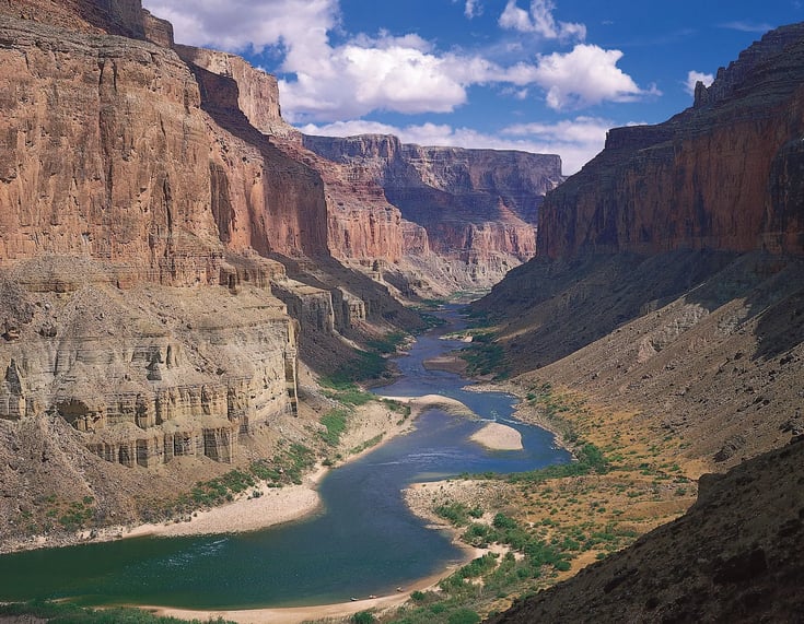
A trip to Arizona would only be complete with a visit to the Grand Canyon, one of the world's most awe-inspiring natural wonders. The Grand Canyon is evidence of the power of water and erosion, as the Colorado River has carved its way through the rock for millions of years. The result is a stunning canyon over a mile deep and 277 miles long. The rock formations in the Grand Canyon also provide a unique glimpse into the region's geological history.
Grand Canyon shuttle options
Sedona's Red Rock Formations
Sedona is known for its stunning red rock formations resulting from the red sandstone erosion that makes up the area's geology. The sandstone was formed over 300 million years ago when a shallow sea covered the area. The red color of the sandstone is due to the presence of iron oxide. The result is a stunning landscape of red cliffs and spires beloved by hikers, photographers, and geologists.
Sedona travel guide
Meteor Crater
Meteor Crater is another fascinating geological site in Arizona. This massive crater was formed over 50,000 years ago when a meteorite collided with the earth. Today, visitors can explore the crater and learn about the geological processes that shaped the landscape. Arizona Shuttle offers tours to Meteor Crater that allow you to learn about the history and geology of the area.
Arizona Shuttle's Geology Tours
Arizona Shuttle offers a range of geology tours that allow you to explore the state's unique landscapes and geological wonders. With experienced guides, comfortable vehicles, and top-of-the-line equipment, you can have an unforgettable experience while learning about the natural forces that shaped the world around us.
Book your tour today and hop in for a journey through Arizona's incredible geology.
Frequently Asked Questions
How old is the petrified wood in Petrified Forest National Park?
The petrified wood formed over 200 million years ago during the Late Triassic Period.
What causes the red color of Sedona's rock formations?
The red color is due to the presence of iron oxide in the sandstone, which was formed over 300 million years ago.
How long did it take for the Colorado River to carve the Grand Canyon?
The carving process took millions of years as the Colorado River eroded through layers of rock.
What can visitors learn at Meteor Crater?
Visitors can explore the crater and learn about the geological processes that occurred when a meteorite collided with Earth over 50,000 years ago.
Antelope Canyon: How Flash Floods Sculpted Arizona's Most Iconic Slot Canyon
Antelope Canyon, located on Navajo Nation land near Page in northern Arizona, is carved into Navajo Sandstone — a formation deposited roughly 190 million years ago during the Jurassic period, when enormous sand dunes blanketed the region. Over millennia, intermittent flash floods carved narrow, swirling corridors through the rock, producing the smooth, wave-like walls that make this the most photographed slot canyon in the American Southwest.
That same carving force is why flash floods remain a genuine danger here, as tragically demonstrated in 1997 when a flash flood killed eleven visitors in Lower Antelope Canyon. This is precisely why all visits require a licensed Navajo guide. Storms falling dozens of miles away can send water racing through the canyon with little warning, even when the sky above you is perfectly blue. If you're planning a trip to Page from Phoenix or Flagstaff, build in flexibility and always respect canyon closures — no photograph is worth the risk.
The San Francisco Peaks: Arizona's Highest Mountains and a Dormant Volcano
North of Flagstaff rises the San Francisco Peaks, the highest point in Arizona and the remnant of a single massive stratovolcano that collapsed on itself long ago. What visitors see today as a ring of summits — including Humphreys Peak — was once the interior of an enormous volcanic mountain. The peaks are a striking reminder that Arizona's volcanic story didn't end millions of years ago; the landscape around Flagstaff is geologically young and still shaped by volcanic forces.
The region surrounding Flagstaff sits atop one of the most extensive volcanic fields in the country, covering approximately 4,700 square miles and containing more than 600 volcanic vents, cinder cones, and lava flows. Sunset Crater, northeast of the city along Highway 89, erupted less than a thousand years ago — a span of time so recent that local Indigenous communities witnessed it and preserved the event in oral tradition. Driving north from Flagstaff toward the Grand Canyon or Page (a route covered in our Flagstaff distance guide), you pass through lava fields, cinder cones, and ponderosa forests that tell this volcanic story in real time.
The Painted Desert and Petrified Forest: When Trees Became Stone
The Painted Desert owes its bands of lavender, pink, and gray to the Chinle Formation, a geological unit deposited roughly 225 million years ago during the Late Triassic period. Within and around it lies Petrified Forest National Park, where over 200 million years ago enormous trees — some reaching 200 feet tall — fell and were buried under volcanic ash and sediment. Silica slowly replaced the organic material, preserving logs in quartz, amethyst, and jasper.
What many visitors miss is the human layer of this story. The park contains over 200 identified archaeological sites, meaning humans have been interacting with this geological wonderland for at least 13,000 years — from ancient hunting camps to Puerco Pueblo, where petroglyphs are etched directly into the same stone story. The park straddles Interstate 40 east of Holbrook, making it one of the easiest major geology stops to add to a cross-state trip.
Monument Valley and the Colorado Plateau's Sandstone Monuments
On the Arizona–Utah border, Monument Valley's towering sandstone buttes and mesas rise hundreds of feet above the desert floor, their layered walls recording ancient dune fields, river deposits, and shallow seas. The valley holds deep cultural significance for the Navajo Nation, within whose territory it sits, and its formations are among the most recognizable landforms on Earth. Reaching it from Phoenix is a serious road trip — roughly 320 miles each way — so travelers often pair it with Page, the Painted Desert, and Flagstaff on a multi-day northern loop rather than a single-day drive.
Montezuma Well and the Verde Valley: Water, Limestone, and Ancient Engineering
South of Flagstaff, in the Verde Valley along I-17, Montezuma Well is one of Arizona's most quietly remarkable geological sites. The "well" is a natural limestone sink, 368 feet across and 55 feet deep, fed by underground springs that pour roughly 1.5 million gallons of water into it every day. The water is warm — around 76°F — and heavily saturated with carbon dioxide, making it uninhabitable by fish and supporting only a tiny set of highly specialized organisms found nowhere else on Earth.
The Sinagua people, who farmed and lived in this area from approximately 700 to 1400 AD, built irrigation canals from the well's outlet — canals that are still partially functional today, over 1,000 years after they were constructed. Nearby, the Verde Valley's geology runs deep in another sense: the valley below Sedona was once the floor of an ancient lake, Lake Verde, which existed during the Pliocene epoch, roughly 2 to 7 million years ago. And in Sedona itself, the famous red rock formations were deposited approximately 330 million years ago from river delta and tidal flat sediments — a landscape whose spiritual resonance for the Yavapai-Apache Nation vastly predates the New Age associations that arrived in the 20th century. Our Sedona travel guide covers how to reach this country from Phoenix.
Arizona's Signature Geological Sites at a Glance
| Site | Signature Feature | Geological Age | Access Point |
|---|---|---|---|
| Grand Canyon South Rim | Layered rock record from Kaibab Limestone to Vishnu basement rock | ~270 million years to ~1.7–1.8 billion years | Village Loop Drive, Grand Canyon, AZ 86023 |
| Meteor Crater | Impact crater ~0.737 miles across, rim 150 ft above the plain | ~50,000 years old | I-40 Exit 233, Winslow, AZ 86047 |
| Petrified Forest & Painted Desert | Chinle Formation and mineralized 200-foot trees | ~225 million years | I-40, east of Holbrook |
| Antelope Canyon | Flash-flood-carved Navajo Sandstone slot canyon | Sandstone ~190 million years old | Near Page, AZ |
| Montezuma Well | Limestone sink, ~1.5 million gallons of spring water daily | Ancient sink; Sinagua canals 700–1400 AD | I-17, Verde Valley |
| San Francisco Peaks / Sunset Crater | Arizona's highest summit and a volcanic field of 600+ vents | Sunset Crater erupted under 1,000 years ago | Highway 89 north of Flagstaff |
How to Read the Grand Canyon's Layers Like a Geologist
Standing at the South Rim for the first time, what strikes you isn't just the size — it's the layers. The pale cream Kaibab Limestone at the top dates to roughly 270 million years ago, laid down when a shallow sea covered this region. Descend in time as you descend in elevation, and near the river you reach black, contorted rock — metamorphic and igneous formations approximately 1.7 to 1.8 billion years old, ancient beyond easy comprehension.
That vertical stack means a single viewpoint compresses more than 1.5 billion years of Earth's history into one glance — the kind of time depth that makes the geological spectacle unfolding across Arizona's 113,990 square miles so overwhelming that a single visit barely scratches the surface, literally and figuratively. Start your first visit at the South Rim Visitor Center on Village Loop Drive, Grand Canyon, AZ 86023, and return to the rim at sunset to watch the layers change color. Shuttle service from Phoenix is available year-round — see our Grand Canyon shuttle options.
Why Arizona's Geology Matters Beyond Tourism
Arizona's formations aren't just scenic backdrops — they are working scientific landscapes. Meteor Crater is where NASA trained Apollo astronauts in the 1960s because its surface most closely mimicked what they expected to find on the Moon. The crater itself records a staggering moment: approximately 50,000 years ago, a nickel-iron meteorite roughly 150 feet in diameter and weighing several hundred thousand tons struck the ground at around 26,000 miles per hour, releasing energy equivalent to roughly 10 megatons of TNT — about 600 times more powerful than the atomic bomb dropped on Hiroshima. The impact punched a hole nearly 4,000 feet across and 560 feet deep, and the rim still rises 150 feet above the surrounding plain.
The viewing platforms at the crater's edge offer a perspective that genuinely unsettles — this is what a 50,000-year-old cosmic wound looks like. Meanwhile, the sedimentary layers of the Colorado Plateau serve as a global reference library for geologists studying ancient climates, deserts, and seas. Understanding this geology also matters practically: flash-flood awareness at Antelope Canyon, water resources in the Verde Valley, and volcanic hazard planning around Flagstaff all depend on reading the rock correctly.
Frequently Asked Questions
How old are the oldest rocks visible in Arizona?
The metamorphic and igneous rocks exposed near the bottom of the Grand Canyon are approximately 1.7 to 1.8 billion years old.
Where is Meteor Crater and how big is it?
Meteor Crater is at Interstate 40, Exit 233, near Winslow, about an hour east of Flagstaff. Today it measures about 0.737 miles in diameter and 550 feet deep, with a rim rising 150 feet above the surrounding plain.
Why did NASA train astronauts at Meteor Crater?
In the 1960s, NASA trained Apollo astronauts there because the crater's surface most closely mimicked what they expected to find on the Moon.
Is Antelope Canyon safe to visit?
Yes, when visited with a licensed Navajo guide. Flash floods remain a genuine danger — a 1997 flood killed eleven visitors — so guided access and closure rules exist for your safety.
What formed the Painted Desert's colors?
The colors come from the Chinle Formation, deposited roughly 225 million years ago during the Late Triassic period.
What makes Montezuma Well unique?
It is a limestone sink 368 feet across and 55 feet deep, fed by roughly 1.5 million gallons of warm (around 76°F), carbon dioxide–saturated spring water daily — home to specialized organisms found nowhere else on Earth.
What is the best base for exploring Arizona's geology?
Phoenix works well for Sedona, the Verde Valley, and Montezuma Well; Flagstaff is the natural base for the Grand Canyon, Meteor Crater, the San Francisco Peaks, and the Painted Desert.
