
Arizona is a state with a rich and diverse history that spans many centuries. From the ancient civilizations that once called the area home to the Wild West and the mining boom of the 20th century, Arizona has played a significant role in molding the history of the United States. traveling from Phoenix to Flagstaff Fortunately, many of the state's most important historical sites are easily accessible by the Arizona shuttle, making exploring the area's past easy. Here's a closer view of some of the top historic sites in Arizona that can be visited with the Arizona Shuttle.
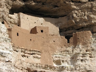
Montezuma Castle National Monument
Montezuma Castle National Monument is a cliffside dwelling built by the Sinagua people around 700 years ago. The five-story structure, which contains 20 rooms, was carved into a limestone cliff and was likely used as a place of worship, storage, and defense. Today, visitors can explore the site and learn about the fascinating history of the Sinagua people who call the area home. Phoenix to Sedona shuttle
Tombstone
Tombstone is a famous Wild West town known for the Gunfight at the O.K. Corral, which took place in 1881. Visitors to Tombstone can explore the historic downtown area, visit museums and exhibits dedicated to the town's history, and even watch reenactments of the famous Gunfight.
Jerome State Historic Park
Jerome is a former mining town once known as the "Wickedest Town in the West." Today, visitors can explore the town's history at Jerome State Historical Park, home to the Douglas Mansion, a 1916 mansion a prominent mining family once owned. Phoenix to Prescott guide The mansion now houses exhibits on the town's history and the mining industry that was once the area's lifeblood.
Casa Grande Ruins National Monument
Casa Grande Ruins National Monument is home to the ruins of a four-story structure built by the Hohokam people over 600 years ago. The structure, made of adobe bricks, is one of North America's most significant prehistoric structures and is evidence of the ingenuity of the Hohokam people.
Hubbell Trading Post National Historic Site
It is a historic trading post established in the late 1800s by John Lorenzo Hubbell. The trading post was a trade center between the Navajo and Hopi tribes and the surrounding area. Today, visitors can tour the trading post and learn about the history of the area's Native American tribes.
These are just countable historical sites that can be explored in Arizona with the Arizona Shuttle. Whether you're interested in the ancient civilizations that once called the area home or the Wild West and mining boom of the 20th century, there's something for everyone to explore in this fascinating state. So why not book your shuttle today and explore Arizona's rich history?
Arizona's History Timeline at a Glance
If you're exploring Arizona's history for the first time, it helps to see the whole sweep of the story in one place. The table below maps each major era to a real site you can visit today, along with the main highway that gets you there. Many of these destinations are reachable from Phoenix with the Arizona Shuttle, so you can build a full historical itinerary without renting a car.
| Era | What Happened | Where to See It | Main Route |
|---|---|---|---|
| Paleo-Indian (pre-8,000 BCE) | Early big-game hunters roam the desert | Arizona State Museum, Tucson | I-10 South |
| Archaic (c. 8,000–1,500 BCE) | Foraging, early farming, petroglyphs | Deer Valley Petroglyph Preserve, Phoenix | I-17 North |
| Post-Archaic / Hohokam & Sinagua | Canals, cliff dwellings, trade networks | Casa Grande Ruins, Montezuma Castle | I-10 / I-17 |
| Spanish & Mexican rule | Missions, presidios, the Gadsden Purchase | Tumacácori National Historical Park | I-19 South |
| Territorial era (1863–1912) | Mining booms, the Long Walk, the Civil War in Arizona | Tombstone, Picacho Peak, Jerome | AZ-80 / I-10 / AZ-89A |
| Modern Arizona (1912–today) | Statehood, dams, Sun Belt growth, water politics | Arizona State Capitol Museum, Phoenix | I-17 / I-10 |
The Paleo-Indian and Archaic Periods: Arizona's Earliest Chapters
Long before any city, mission, or mine existed, Paleo-Indian peoples moved across what is now southern Arizona, hunting large Ice Age game and leaving behind stone projectile points that archaeologists still study today. The Arizona State Museum in Tucson, located on the University of Arizona campus near the historic West University neighborhood, holds one of the Southwest's most important collections of these early artifacts.
The Archaic period that followed saw communities adapt to a warming, drying desert. People learned to grind wild seeds, plant early corn, and leave the rock-art panels you can still see at the Deer Valley Petroglyph Preserve in north Phoenix, just off I-17. These carvings are among the oldest visual records in the state — a reminder that exploring Arizona's history begins thousands of years before written documents.
The Post-Archaic Period: Canals, Cliffs, and Vanished Cities
The Hohokam people of the Phoenix basin built canal systems over 1,000 years ago that rival modern engineering, redirecting Salt River water across miles of desert farmland. In a striking echo of that legacy, Phoenix's modern canal network and the city's very name — the mythical bird reborn from ashes — grew directly on top of Hohokam ground. Yet by around 1450 CE, the Hohokam had vanished from the historical record, likely due to drought and overuse of resources — a story with uncomfortable relevance to Arizona's current water debates.
To the north, the Sinagua built the five-story cliff dwelling at Montezuma Castle along Beaver Creek, reachable off I-17 near Camp Verde. Farther north and east, the Ancestral Puebloans left behind monumental structures on the Colorado Plateau. The Hopi people are one of the oldest living cultures in North America, and Oraibi, a Hopi village on Third Mesa dating back to at least 1150 AD, is believed to be the oldest continuously inhabited settlement in the United States. The Hopi mesas lie in northeastern Arizona, within the Navajo Nation's surrounding lands — a region best visited with local guides and respectful planning.
Spanish and Mexican Arizona: Missions, Presidios, and the Gadsden Purchase
Spanish missionaries arrived in the 1600s, followed by Mexico's brief rule after independence. Father Eusebio Kino's mission network left behind Tumacácori National Historical Park along the I-19 corridor south of Tucson, one of the oldest European-built sites in Arizona. The Mission San Xavier del Bac, the gleaming white church on the Tohono O'odham Nation's lands just south of downtown Tucson, remains an active parish and a masterpiece of Spanish colonial architecture.
The land was ceded to the United States in 1848 under the Treaty of Guadalupe Hidalgo, and the 1854 Gadsden Purchase finalized the U.S.–Mexico line across southern Arizona. But for Indigenous nations like the Tohono O'odham, whose traditional lands straddle the border, the new line split communities overnight — a historical wound that still shapes border debates today.
The Long Walk: A Defining Tragedy of Territorial Arizona
The Navajo (Diné) arrived in the southwestern United States roughly 800 to 1,000 years ago and became livestock farmers after the Spanish arrived in the mid-16th century. As American expansion pushed into their homelands, Colonel Kit Carson planned a scorched-earth campaign in 1863 to force their surrender. The result was the "Long Walk": more than 8,500 Diné people were forced to walk some 300 miles over two months from northeastern Arizona and northwestern New Mexico to the Bosque Redondo Reservation near Fort Sumner, and about 200 died from starvation and exposure along the way. Four years later, the U.S.–Navajo Treaty of 1868 allowed them to return, establishing the Navajo Nation — today the largest Native American reservation in the country, spanning vast lands of northern Arizona's high desert and black-forested mountain country.
When the Civil War Came to Arizona: The Battle of Picacho Pass
Arizona wasn't a bystander in the Civil War. On April 15, 1862, Union cavalry from California clashed with Confederate pickets at Picacho Pass, the westernmost battle of the war's New Mexico–Arizona theater. Today, Picacho Peak State Park — the jagged volcanic landmark rising alongside I-10 between Phoenix and Tucson — marks the site, and reenactments draw visitors each year. It's one of the easiest historical stops to add to a southern Arizona shuttle itinerary.
Territorial Oddities: The 1929 Siege of Naco and the 1934 Colorado River "War"
Arizona's territorial and early-statehood past includes stories stranger than fiction. In 1929, during Mexico's Cristero Rebellion, bullets and bombs from the fighting in Naco, Sonora actually landed across the line in Naco, Arizona — an early-state town on the border southeast of Tucson that found itself under fire. And in 1934, Arizona's governor sent the National Guard to the Colorado River to stop California from diverting water behind Parker Dam — a genuine, if bloodless, "river war" between states that foreshadowed a century of Colorado River disputes. History.com's Arizona state profile captures how these conflicts helped define the young state's identity.
Statehood in 1912 and the 5 Cs
Arizona became a separate territory in 1863 and officially earned its statehood on February 14, 1912 — the last of the contiguous 48 states. Old-timers still describe the state's early economy through the "5 Cs": copper, cattle, cotton, citrus, and climate. You can trace that story at the Arizona State Capitol Museum at Wesley Bolin Plaza near downtown Phoenix, and copper mining's boomtowns — Jerome on Cleopatra Hill above the Verde Valley, reached by the winding switchbacks of AZ-89A — still cling to the mountainsides where they were built.
After 1945: Sun Belt Boom and the Myth of Limitless Water
After World War II, air conditioning and federal dams — most famously Hoover Dam on the Colorado River along the Arizona–Nevada line — turned Arizona into a Sun Belt paradise. Politicians promised "water forever," but the 2023 Tier 2 shortage declaration on the Colorado River proved otherwise. With roughly 40% of Arizona's water going to agriculture — much of it for water-intensive crops like alfalfa, some exported overseas — critics ask why hay is grown in a desert while Phoenix suburbs face cutbacks. Meanwhile, Phoenix just endured 31 straight days of 110°F-plus temperatures in the summer of 2023, proof that the climate crisis is already rewriting the state's story. History is repeating itself in real time: like the Hohokam, modern Arizonans are learning that desert water is never guaranteed.
The Border: History in Today's Headlines
Arizona's border story is long and layered. In the 1990s, the federal Operation Gatekeeper crackdown funneled migration routes into Arizona's deadly Sonoran Desert, where humanitarian groups such as No More Deaths continue to leave water stations in Ajo and along desert trails. The debate is not new — it echoes the 19th-century land seizures that redrew the map — but it now unfolds with surveillance towers and social media coverage. Understanding the Gadsden Purchase and the Tohono O'odham border split gives today's headlines essential context.
Sedona and the Instagram Effect on History
Not all of Arizona's modern history is political. The red-rock country around Sedona, reached via AZ-89A through the gorgeous switchbacks of Oak Creek Canyon, has been transformed in recent decades into a spiritual tourism mecca — vortex sites, wellness retreats, and crowds seeking self-care among cliffs that hold ancient Sinagua dwellings. Even a scenic sunset photo spot carries layers of Indigenous history worth knowing before you visit.
Frequently Asked Questions About Exploring Arizona's History
What is the oldest continuously inhabited place in Arizona?
Oraibi, a Hopi village on Third Mesa in northeastern Arizona, dates back to at least 1150 AD and is believed to be the oldest continuously inhabited settlement in the United States.
When did Arizona become a state?
Arizona became a U.S. territory in 1863 and achieved statehood on February 14, 1912, making it the last of the contiguous states to join the Union.
Which prehistoric sites can I visit in Arizona?
Top options include Montezuma Castle National Monument near Camp Verde, Casa Grande Ruins National Monument near Coolidge, and Tuzigoot National Monument in the Verde Valley — all reachable from Phoenix by highway.
What were the 5 Cs of Arizona's economy?
Copper, cattle, cotton, citrus, and climate — the five pillars that drove Arizona's early territorial and statehood economy.
Why did the Hohokam civilization disappear?
Researchers believe a combination of drought and overuse of natural resources led to the Hohokam's disappearance from the Phoenix area by around 1450 CE, after centuries of sophisticated canal irrigation.
Can I explore Arizona's historic sites without a car?
Yes. Many historic destinations near Phoenix, Flagstaff, and Tucson can be reached with scheduled shuttle service, and the Arizona Shuttle offers connections that make car-free historical travel practical for major corridors.
