
Nestled in the central highlands of Arizona, Prescott is surrounded by stunning natural beauty, numerous wilderness areas, and national forests. Whether you're a hiker, camper, or nature lover, there are ample opportunities to explore the great outdoors in and around Prescott. And with Arizona Shuttle, getting there has always been challenging. Phoenix to Prescott travel guide Phoenix to Prescott shuttle
Here's a guide to some of the top wilderness areas and national forests in the area that are worth exploring:
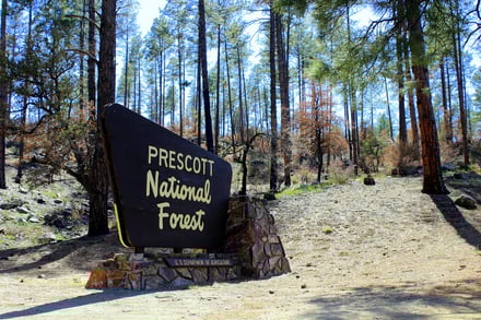
Prescott National Forest
Covering over 1.2 million acres, the Prescott National Forest is a vast and diverse wilderness area perfect for outdoor recreation. There are numerous trails for hiking, mountain biking, camping, fishing, and wildlife watching. The forest also features several lakes and streams, including Lynx Lake, Watson Lake, and Granite Basin Lake, popular spots for boating and fishing.
Granite Mountain Wilderness
Located just north of Prescott, the Granite Mountain Wilderness is a rugged and scenic area home to various plant and animal species. Wildlife in the area includes elk, mountain lions, and black bears. The wilderness area features several hiking trails, including the famous Granite Mountain Trail, which offers breathtaking views of the surrounding landscape.
Tonto National Forest
Stretching over 2.8 million acres, Tonto National Forest is the fifth-largest national forest in the country and offers a wealth of outdoor activities. The forest is home to the iconic Superstition Mountains and several lakes, rivers, and streams, perfect for fishing, boating, and swimming. There are also numerous trails, including the popular Apache Trail, which winds through the stunning Salt River Canyon.
Sedona Red Rock Country
Just a short drive from Prescott, Sedona Red Rock Country is a stunning area known for its towering red rock formations and scenic hiking trails. Phoenix Airport to Sedona shuttle The site is also famous for its spiritual and healing energy and has several spas and wellness centers. Sedona trip cost breakdown Several trails offer spectacular views of the surrounding landscape, including the Cathedral Rock Trail and the Bell Rock Pathway.
Prescott Circle Trail
Suppose you're looking for an extraordinary way to explore the natural beauty of Prescott. In that case, the Prescott Circle Trail is a 54-mile loop trail that circles the city and passes through some of the most stunning wilderness areas. The trail is open to hikers, mountain bikers, and equestrians and can be completed in segments or all at once.
With Arizona Shuttle, you can easily access these wilderness areas, national forests, and more. Whether you're looking to hike, bike, or take in the area's stunning natural beauty, there's something for everyone in and around Prescott.
More Wilderness Areas Managed by the Prescott National Forest
Beyond Granite Mountain, the Prescott National Forest protects a network of designated wilderness areas that many first-time visitors never hear about. According to the U.S. Forest Service, the forest contains roughly 100,000 acres of wilderness and about 950 miles of hiking, biking, and horseback riding trails. Here are the additional wilderness areas that round out Prescott's backyard.
Apache Creek Wilderness
Established in 1984, this 5,628-acre wilderness features three natural springs and several important riparian areas, including Apache Creek itself. Elevations range from 5,200 to 6,900 feet, and the mix of canyon country and water sources provides excellent habitat for mountain lions and numerous bird species, making it a favorite with birders who want solitude. If you're planning a group trip, note the access rules: hiking groups are limited to 15 people and equestrian groups to 10 animals.
Juniper Mesa Wilderness
Also established in 1984, the 7,554-acre Juniper Mesa Wilderness is characterized by the flat-topped mesa from which its name is derived. Elevations range from about 5,600 feet on the southwest side near Juniper Spring up to 7,000 feet on the west side near George Wood Canyon and Gobblers Knob. This is a genuinely remote destination — access is via unpaved roads, and a high-clearance vehicle is recommended. It sits near Apache Creek Wilderness on the western edge of the Chino Valley Ranger District. Seven maintained trails serve the area, including Trails #3, #20, #100, #9853, and #940.
Woodchute Wilderness
Created in 1984, the 5,923-acre Woodchute Wilderness ranges in elevation from 5,500 to 7,800 feet, giving it one of the largest elevation spreads of any wilderness on the forest. That vertical range translates into varied terrain and vegetation as you climb, and the area's history runs deep: as early as the mid-1800s, mining first brought settlers to this part of Arizona.
Granite Mountain Wilderness: Trails and Ground Rules
The rugged wilderness takes its name from 7,623-foot Granite Mountain, whose granite bulk dominates the skyline northwest of downtown. Trails within the wilderness include Granite Mountain Trail #261, Tin Trough Springs Trail #308, and the Baby Granite Loop. Two rules every visitor should know before lacing up: camping is not permitted within 200 feet of Granite Mountain Trail #261, and group sizes are capped at 15 hikers and 10 stock animals. State Route 89 provides access to the northern portions of the forest, including the Granite Mountain Wilderness Area, while Forest Road 318 and smaller paved or gravel roads connect to more remote camping and hiking spots.
Pine Mountain Wilderness
Toward the southern reaches of the forest, the Pine Mountain Wilderness offers a half-dozen maintained routes for hikers ready to go deeper: Nelson Trail #159, Buck Basin Trail #158, Pine Flat Trail #165, Tule Rim Trail #162, Verde Rim Trail #161, and Willow Springs Trail #12. Its position along the Verde River country makes it a good pick for visitors who have already hiked the trails closer to town.
Sycamore Canyon, Castle Creek, and Cedar Bench
The Sycamore Canyon Wilderness, in the red rock country northeast of Prescott, winds for 20 miles along Sycamore Creek and at places stretches 7 miles from rim to rim. Wind and water have exposed seven geological associations of plants and animals in a spectacular setting of red sandstone, white limestone, and brown lava — a striking counterpoint to the granite and pine country around Prescott itself. The Castle Creek Wilderness and Cedar Bench Wilderness, both managed within the Prescott National Forest system, complete the picture for travelers who want to say they've explored every wild corner of the forest.
Prescott Wilderness Areas at a Glance
Use this quick comparison to match a wilderness area to your trip style.
| Wilderness Area | Size | Elevation Range | Best For |
|---|---|---|---|
| Granite Mountain | — | Summit at 7,623 ft | Day hikes close to town; views from Trail #261 |
| Apache Creek | 5,628 acres | 5,200–6,900 ft | Birdwatching; riparian spring-fed habitat |
| Juniper Mesa | 7,554 acres | ~5,600–7,000 ft | Remote, high-clearance-vehicle backcountry |
| Woodchute | 5,923 acres | 5,500–7,800 ft | Elevation-gain hikes; mining-era history |
| Pine Mountain | — | — | Six maintained trails; Verde River country |
| Sycamore Canyon | — | — | Red sandstone, limestone, and lava geology |
What Is the History of the Prescott National Forest?
The human history of what is now the Prescott National Forest dates back at least 10,000 years, according to prehistoric evidence. In the mid-19th century, the area saw dramatic change as European-American settlers flooded in after gold was discovered in the Bradshaw Mountains, resulting in the forced removal of the Yavapai people. In 1935, the Yavapai Prescott Indian Tribe regained a small reservation near Prescott, where the community remains today.
The forest itself has an official birthday, too: the Prescott Forest Reserve was established in 1898, later becoming Prescott National Forest in 1908 when it absorbed neighboring reserves. Reminders of that mining and timber era are everywhere — from the historic structures in the Bradshaws to Sycamore Cabin, an eight-person cabin at 4,000 feet in elevation that was constructed in 1938 by the Civilian Conservation Corps and is available to rent. At the top of the Bradshaws, Mount Union stands as the highest elevation in the forest at nearly 8,000 feet.
How to Get to the Prescott National Forest
Coming south from Phoenix or north from Flagstaff, Interstate 17 and State Route 69 lead to Prescott, the forest's main gateway city. Travelers arriving by air can book a Phoenix to Prescott shuttle through Arizona Shuttle and be at the edge of trail country without navigating mountain highways themselves.
Once you're in Prescott, State Route 89 provides access to the northern portions of the forest, including the Granite Mountain Wilderness Area, while Forest Road 318 and smaller paved or gravel roads connect to more remote camping and hiking spots. Remember that Juniper Mesa and similar backcountry destinations require unpaved-road travel, so a high-clearance vehicle is recommended before you commit to the drive.
What's the Best First-Timer's Adventure in the Prescott National Forest?
Start with the Lynx Lake Recreation Area. Set among ponderosa pines at 5,000 feet in elevation, it's a cool escape during the summer months. The serene 55-acre lake provides trout fishing and boating, there are two campgrounds if you want to stay overnight, and a number of trails thread through the surrounding forest — all within a short drive of downtown Prescott. If day one goes well and you're ready for a bigger challenge, point your boots at Granite Mountain Trail #261 for views of the rugged wilderness from 7,623-foot Granite Mountain.
Plan Your Visit: Visitor Resources
Before heading out, check current conditions, fire restrictions, and road status — forest roads and wilderness access can change with the weather. For more information or questions, visit the official forest site at https://www.fs.usda.gov/r03/prescott. A few practical reminders from the land-management agencies: respect wilderness group limits (15 hikers, 10 stock animals), keep at least 200 feet off Granite Mountain Trail #261 when choosing a campsite, and pack out everything you pack in. And if you'd rather leave the driving to someone else, Airport Shuttle of Phoenix can get you from the airport to Prescott so your adventure starts the moment you land.
Frequently Asked Questions About Prescott's Wilderness Areas and National Forests
How many wilderness areas are near Prescott?
The Prescott National Forest contains roughly 100,000 acres of designated wilderness, including Granite Mountain, Apache Creek, Juniper Mesa, Woodchute, Pine Mountain, Castle Creek, and Cedar Bench wildernesses, with Sycamore Canyon Wilderness nearby in the red rock country.
When was the Prescott National Forest established?
The Prescott Forest Reserve was established in 1898 and became Prescott National Forest in 1908, when it absorbed neighboring reserves. Individual wilderness areas within the forest, such as Apache Creek and Juniper Mesa, were designated in 1984.
What is the highest point in the Prescott National Forest?
Mount Union, in the Bradshaw Mountains, is the highest elevation in the forest at nearly 8,000 feet. Granite Mountain, at 7,623 feet, is the most recognizable summit near town.
Do I need a high-clearance vehicle to visit these wilderness areas?
Not everywhere. Granite Mountain is reached via State Route 89 and paved roads, but remote areas like Juniper Mesa are accessed via unpaved roads where a high-clearance vehicle is recommended. Forest Road 318 and smaller gravel roads serve more remote camping and hiking spots.
Are there group size limits in the wilderness areas?
Yes. Hiking groups are limited to 15 people and equestrian groups to 10 animals, so split larger parties across separate trailheads or contact the forest service for guidance.
Can I fish and camp near Prescott?
Yes. Lynx Lake Recreation Area offers trout fishing, boating, and two campgrounds at 5,000 feet in elevation, and the forest's lakes and streams — including Lynx Lake, Watson Lake, and Granite Basin Lake — are popular bases for camping and fishing trips.
Where can I get current trail and road conditions?
Check the official Prescott National Forest website at fs.usda.gov/r03/prescott before your trip for the latest conditions, restrictions, and alerts.
